
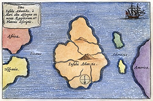
Map Of Atlantis 1678 Natlantis As A Very Large Island Midway Between The Pillars Of Hercules And America Is Depicted In This Map From Athanasius KircherS Mundus Subterraneus 1678 Poster Print by (24
Product Description
Map Of Atlantis 1678 Natlantis As A Very Large Island Midway Between The Pillars Of Hercules And America Is Depicted In This Map From Athanasius KircherS Mundus Subterraneus 1678 Poster Print by (24
- Map Of Atlantis 1678 Natlantis As A Very Large Island Midway Between The Pillars Of Hercules And America Is Depicted In This Map From Athanasius KircherS Mundus Subterraneus 1678
Technical Specifications
You might also like

AOOVOO Cinnamon Scented Candles for Women - Aromatherapy Candle with Crystals Inside, 10oz Soy Candles for Home Scented, Birthday Gifts Valentines Day Candle for Women Mom

FMFUNCTEX 100% Blackout Blush Pink Curtains 72 Inches for Bedroom, 2 Panels

Ahaorigin 12 Pack Solar Pathway Lights Outdoor, 12 Brighter LED Solar Lights Outdoor Waterproof, Up to 12 Hrs Modern Path Light for Yard Garden Walkway Driveway Lawn, Cool White

KIYOYO Lemon Metal Sign Vintege Gather In Our Kitchen Tin Poster Home Barthroom Kitchen Bar Pub Wall Decor 12x8 Inch

Lineshading 4 Pcs Fall Decoration For Home Wooden Maple Leaf Stacked Decor

FMFUNCTEX 100% Blackout Black Curtains 84 Inches for Bedroom, 2 Panels
FMFUNCTEX 100% Blackout Blush Pink Curtains 84 Inches for Bedroom, 2 Panels

FMFUNCTEX 100% Blackout Beige Curtains 40x84 Inches for Bedroom, 2 Panels