
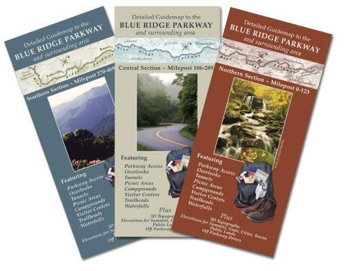
Detailed Guidemap to the Blue Ridge Parkway & Surrounding Area Complete Set (Southern, Central and Northern Sections, 3 maps)
Product Description
Detailed Guidemap to the Blue Ridge Parkway & Surrounding Area Complete Set (Southern, Central and Northern Sections, 3 maps)
In addition, major recreation areas, Forest Service campgrounds, and waterfalls are shown. Plus, many backroads are detailed making this map an invaluable guide to scenic drives as well as a recreational resource for areas surrounding the Parkway.
These three maps cover the Parkway from the beginning of the Parkway near Asheville, North Carolina until its end near Waynesboro, Virginia.
Map scale is 1/2 inch = 1 mile.
A portion of sales for this map goes to the Blue Ridge Parkway Foundation. Save on shipping by buying this three pack of maps, or the Central/Southern 2-pack or the Central/Northern 2-pack. You may also buy each map individually if you don't need more than one section.
Technical Specifications
You might also like

Moon Blue Ridge Parkway Road Trip: Including Shenandoah & Great Smoky Mountains National Parks (Moon Handbooks)

Guide to the Blue Ridge Parkway

Hiking and Traveling the Blue Ridge Parkway: The Only Guide You Will Ever Need, Including GPS, Detailed Maps, and More (Southern Gateways Guides)

Blue Ridge Parkway (National Geographic Destination Map)

Detailed Guidemap to the Blue Ridge Parkway and Surrounding Area: Southern Section

Best Easy Day Hikes Blue Ridge Parkway (Best Easy Day Hikes Series)
Shenandoah National Park (National Geographic Trails Illustrated Map)

Bicycling the Blue Ridge: A Guide to the Skyline Drive and the Blue Ridge Parkway

Best of the Blue Ridge Parkway: The Ultimate Guide to the Parkway's Best Attractions

The Photographer's Guide to the Blue Ridge Parkway: Where to Find Perfect Shots and How to Take Them (The Photographer's Guide)